Posts: 218
Threads: 3
Likes Received: 0 in 0 posts
Likes Given: 0
Joined: Jun 2006
Reputation:
0
Finally…after months of snow, rain, Work Drama and other such stuff…a new fire station post. These pics were actually taken back in late October and early November last year (Before we knew just what kind of winter we were in for!
So, without further ado!
The City of Chesapeake…And here it starts to get interesting (This happens a LOT in The Seven Cities, BTW).
http://cityofchesapeake.net/services/dep...ions.shtml Chesapeake Fire Station Map
The city is shaped somewhat like a medieval knight wearing a cape (This hiding his legs), looking back over his left shoulder with his back to you and his left arm upraised. Chesapeake’s bordered by Portsmouth and Norfolk to the north, Va. Beach to the east, North Carolina to the south, and Suffolk to the west. The great majority of the city’s western quarter or so (From below the knight’s left armpit all the way down to the NC State Line) is Great Dismal Swamp, with Lake Drummond tucked into the southwest corner of the city. The northwestern panhandle (The upraised arm), and the northern, and central portions of the city are the most densely populated areas with the eastern, southern and western portions of the city being the most rural. I believe Chesapeake was Virginia’s largest city area-wise until the consolidation of Nansemond County and Suffolk in ’74.
Chesapeake has only been in existence since 1963. The area that’s now The City of Chesapeake was once comprised of Norfolk County and The City of South Norfolk. The City of South Norfolk was tucked up into the north-central portion of the present City of Chesapeake (South Norfolk formed what’s now essentially the knight’s helmet) The small city was basically landlocked within Norfolk County, which was being pecked away from the North by both Norfolk and Portsmouth. In fact South Norfolk would have been left surrounded by Norfolk in one annexation suit by that city.
Beginning in 1961 a series of meetings, referendums, and discussions occurred, with a vote to consolidate South Norfolk and Norfolk County, the new city taking the name Chesapeake when the consolidation became official in 1963 (And if you think it went that smoothly, just remember…Politics were involved! That is a story worthy of it’s own book, or part of one, and in fact, is. )
From a fire buff’s stand point, this left former Norfolk County stations and station sites scattered across portions of three cities…am I gonna have fun or WHAT?!
Now the numbers and such:
The Chesapeake Fire Department is a combination department protecting 220,000 people living in just over 350 square miles, running 17 engines, 3 truck companies, a pair of heavy rescues, a fire boat, and numerous special pieces out of 15 stations.
CFD protects a very diverse and varied area, with the harbor of Hampton Roads to the north, and miles of rural countryside abutting The Great Dismal Swamp to the south. Within this area they protect a busy general aviation airport, a US Navy Auxiliary field, portions of 4 Interstate highways,( 64, 264, 464, 664) 4 US highways (13, 17, 58, 460) and State Rout 168. Five railroads pass through Chesapeake (CSX, Norfolk Southern, and a trio of short lines) as well as a portion of the Intracoastal Waterway (Including a system of locks). CFD also protects miles of waterways, a large coal powered power plant, numerous marine-related industries (The Essex Class carrier USS Franklin was scrapped at Portsmouth Salvage Company, within sight of the The Gilmerton Bridge, which carries US 13 over the Elizabeth River), Innumerable medium and light industrial occupancies, vast reaches of rural woods and farmland, a sizable chunk of The Great Dismal Swamp including Lake Drummond, several historical districts, and some HUGE homes, many of them in the southern portion of the city where water supply can be, shall we say, limited.
An interesting note…Chesapeake has more bridges than any other city in Virginia (And its own bridge maintenance division to prove it!) and THEY lost a bridge recently as well. These bridges form their own kind of challenge as several of the older ones have weight restrictions that keep fire apparatus from using them.
The weather fooled me on the Sunday I picked to shoot the first 10 stations. The sky was clear and bright blue in Chester when I left the house, but clouded quickly as I headed east on U S 460…I was educated on just what ‘Partly Sunny’ actually means. (Apparently it’s actually a P. C. way of saying ‘Mostly Cloudy) as well as being reacquainted with just what the wind that close to the water can feel like. ( C-C-C-Cold…the wind was whipping that day, as the flags confirm!)
All in all it wasn’t bad at all, though, and I had a blast getting the shots.
About a week later, I took advantage of the truly strange work schedule I had at the time, and shot the last five stations (And reshot one) on one of the prettier Wednesdays that Fall in Tidewater can offer up.
Now to the stations
Station 1 South Norfolk
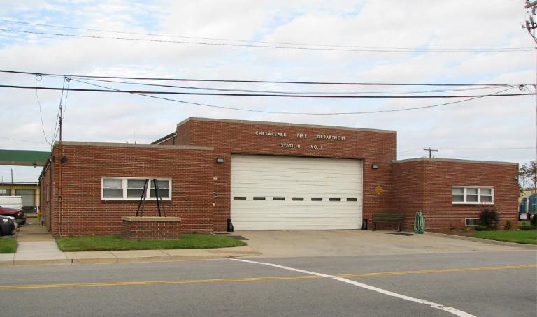
Station 1 was actually the third station I shot. The present Station 1, (South Norfolk) at 1201 20th Street was opened in 1969, and presently runs 3000+ calls a year. An engine, a medic, and a foam rig are assigned to the station. The station is in the extreme northern portion of the city, right at the knight’s forehead, and is the top point of a five pointed star formed by stations 1,2,3,4, and 14
Engine 1 to all units, we've got a glow in the sky!
If God's not a Hokie, Then why do the leaves turn Maroon and Orange in the Fall?
My [url="http://www.flickr.com/photos/fotowun/"]Flickr Account[/url]
Posts: 218
Threads: 3
Likes Received: 0 in 0 posts
Likes Given: 0
Joined: Jun 2006
Reputation:
0
The Chesapeake Fire Department started out as the South Norfolk Volunteer Fire Department in 1892, and the newly organized department purchased a hose reel and 400 feet of hose. The station was at Liberty and Seaboard Streets, and (Like all of South Norfolk’s old stations) is long gone. The department became inactive, and was again reorganized in 1909, with the new station at 22nd and ‘B’ streets. In 1915 a two story station was built directly across from the old station, which was sold to pay the debt on the new building (Local legend has it that the sale was actually to pay off the debt on the feed bill for the department’s horse, which was also sold!)
In 1917 the department was motorized and shortly after, the station was moved to the 700 block of Liberty Street in a converted blacksmith’s shop. This station was replaced by another, also on Liberty Street. The new station was built about 1930, and was a classic two story brick storefront with the fire station on the first floor and City Hall on the second. (While I have access to a picture it’s not available for use do to copyright issues). South Norfolk was a volunteer/Paid On Call department at the time, and was considered to be one of the best equipped volunteer departments in the state. Interestingly enough, one of the innovations pioneered by South Norfolk was A primitive version of EMS, with a fire department staffed ambulance.
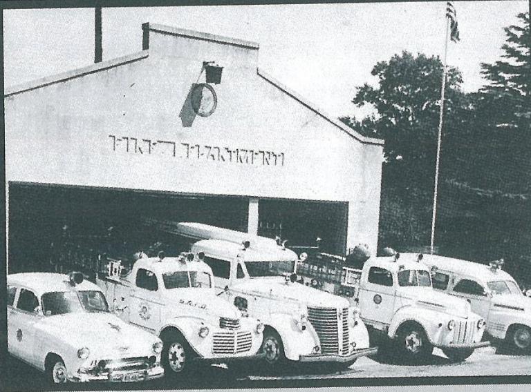
The first Chesapeake (And last South Norfolk) Station 1. Picture taken in the early to mid '50s when thi was still South Norfolk Station 1
Used with Permission of CFD Capt Sam Gulisano
This station lasted until the early 50s when the first salaried firefighters were hired and a new station was built in the 600 block of Liberty Street (I have a feeling it was on the site of the old fire station/City Hall) This station became he first Chesapeake Station 1, and while Google maps actually lists it as an existing building, it too is, sadly, long gone. This station was, of course, replaced by the current Station 1
Engine 1 to all units, we've got a glow in the sky!
If God's not a Hokie, Then why do the leaves turn Maroon and Orange in the Fall?
My [url="http://www.flickr.com/photos/fotowun/"]Flickr Account[/url]
Posts: 218
Threads: 3
Likes Received: 0 in 0 posts
Likes Given: 0
Joined: Jun 2006
Reputation:
0
Station 2 Portlock
Station 2 …located is on Freeman Street just off of Bainbridge Ave directly behind the old Portlock Elementary School, which itself can clam a big part in Station 2’s early history. This station regularly ranks in Firehouse Magazine’s 100 busiest Stations and is nicknamed ‘The House of the Sleepless Nights’ by the members. Station 2 is almost due south of Station 1, located just below the knight’s chin, and forms the left point of the star. An engine, a ladder, a medic, a utility rig, and a foam trailer are assigned to Station 2
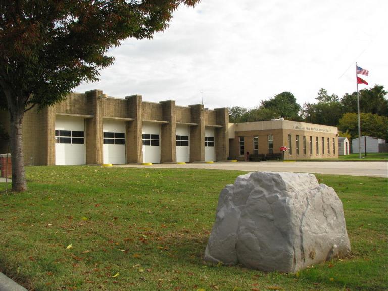
Everyone was out training when I stopped by, leaving only the captain doing paperwork and such.
Station 2 is the only fire company in Chesapeake to have served Norfolk County, South Norfolk, and Chesapeake. The company started out as the Portlock Volunteer Fire Department in the unincorporated Norfolk County village of Portlock.
Engine 1 to all units, we've got a glow in the sky!
If God's not a Hokie, Then why do the leaves turn Maroon and Orange in the Fall?
My [url="http://www.flickr.com/photos/fotowun/"]Flickr Account[/url]
Posts: 218
Threads: 3
Likes Received: 0 in 0 posts
Likes Given: 0
Joined: Jun 2006
Reputation:
0
Station 2 had 3 previous locations (All long gone). The fire company was organized in 1923 and it’s first rig was a vehicle towed hose reel, stored in the garage of one of it’s members. The first motorized piece of apparatus was a model ‘T’ tow vehicle…A Buick was donated a couple of years later and converted to a hose and equipment wagon.
Portlock's first fire station, built in 1928, was a tin shed at Bainbridge and Freeman next to the school on land donated by the school board, with the same apparatus…an actual pumper wasn’t obtained until a Chevy pumper was purchased in the early ‘30s. An additional bay was built onto the station to house this rig. Portlock also ran an ambulance early on, beginning I the early ‘30s.
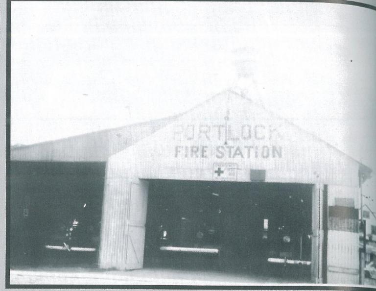
The first Portlock Volunteer Fire Departmet station, in Norfolk County. This picture was apparently taken in the mid 40's, near the end of this station's life. The Pirsch is barely visible in the bay, and if you squint hard you can make out the house siren on the roof
Again, Thanks to CFD Capt Sam Gulisano
This station lasted until 1944, when Norfolk County purchased a new Pirsch 750GPM pumper for the fire company (N C F D was apparently a loyal Pirsch customer in the Forties and Fifties)) and this rig really pushed the crew at Portlock for space.
Engine 1 to all units, we've got a glow in the sky!
If God's not a Hokie, Then why do the leaves turn Maroon and Orange in the Fall?
My [url="http://www.flickr.com/photos/fotowun/"]Flickr Account[/url]
Posts: 218
Threads: 3
Likes Received: 0 in 0 posts
Likes Given: 0
Joined: Jun 2006
Reputation:
0
A new 2 story brick station was built on the approximate site of the present station. This station became South Norfolk Station 2 when that city annexed Portlock in 1951 (South Norfolk grabbed it’s share of Norfolk County, too.)
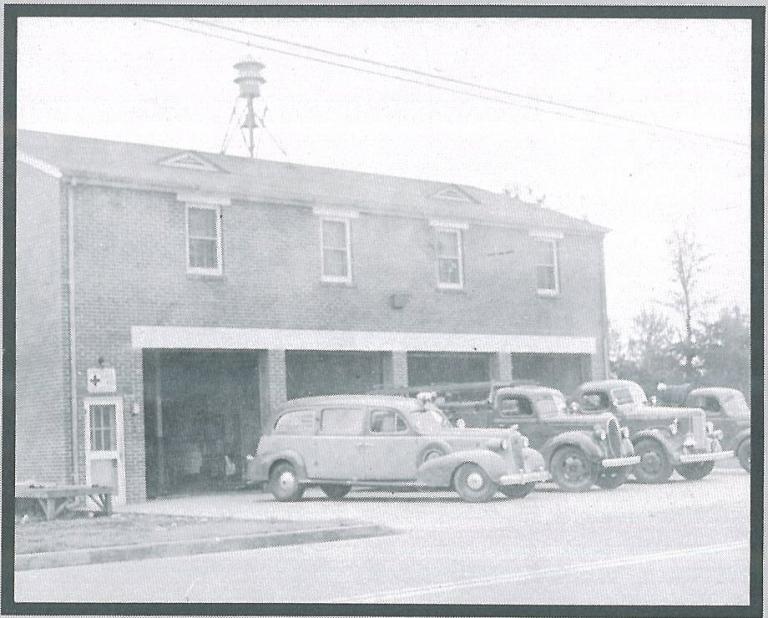
Portlock's new station, built in '44 and Still a Norfolk County station.
Thanks to CFD Capt Sam Gulisano
Engine 1 to all units, we've got a glow in the sky!
If God's not a Hokie, Then why do the leaves turn Maroon and Orange in the Fall?
My [url="http://www.flickr.com/photos/fotowun/"]Flickr Account[/url]
Posts: 218
Threads: 3
Likes Received: 0 in 0 posts
Likes Given: 0
Joined: Jun 2006
Reputation:
0
Twelve years later when South Norfolk and Norfolk County consolidated to form Chesapeake it became Chesapeake Station 2. A new 2 bay addition was added to the B side of the station to accommodate modern apparatus.
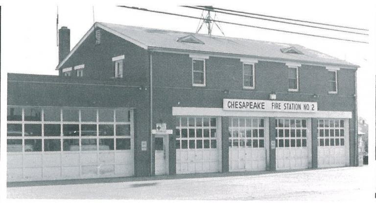
Old Portlock as Chesapeake Station 2. The station also served as South Norfolk Station 2
Thanks to CFD Capt Sam Gulisano
Engine 1 to all units, we've got a glow in the sky!
If God's not a Hokie, Then why do the leaves turn Maroon and Orange in the Fall?
My [url="http://www.flickr.com/photos/fotowun/"]Flickr Account[/url]
Posts: 218
Threads: 3
Likes Received: 0 in 0 posts
Likes Given: 0
Joined: Jun 2006
Reputation:
0
Station 3 Indian River (Washington Borough)
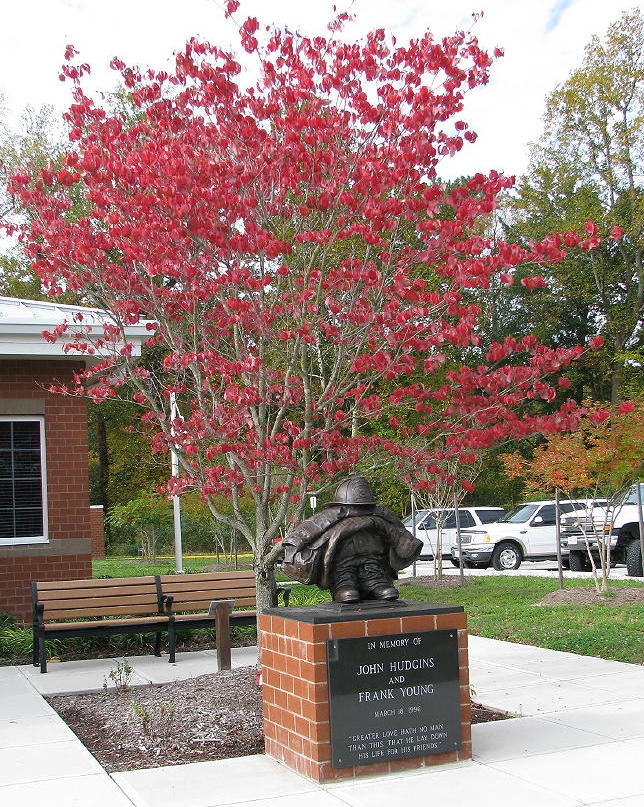
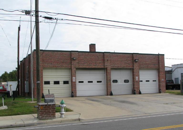
Station 3 is located on Rokeby Ave, at the back of the knight’s head, and forms the right hand point of the star. The present Station 3 is directly across from their old house, and was only about six months old when I grabbed shots of it…the station opened In March 09 and was dedicated to John Hudgins and Frank Young of Engine 3, both of whom gave the Supreme Sacrifice while operating at a major fire in an auto parts store on March 18th, 1996. The stations landscaping includes a permanent memorial to them at the front entrance to the building.
Link to story about the dedication of Chesapeake Station 3 http://hamptonroads.com/2009/03/chesapea...en-members
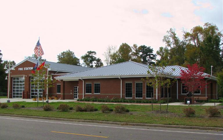
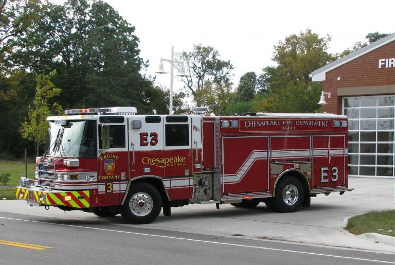
Chesapeake is building some seriously nice (And big) stations, and Station 3 is no exception…the building is even more impressive up close than it is in pictures, and includes every amenity that you’d want in a modern fire station. I was just about to get the nickel tour when Engine 3 was dispatched on a medical, Still got some good shots of Station 3, as well as Engine 3 (With one of the new Pierce P. U. C.s) hiting the street.
Engine 1 to all units, we've got a glow in the sky!
If God's not a Hokie, Then why do the leaves turn Maroon and Orange in the Fall?
My [url="http://www.flickr.com/photos/fotowun/"]Flickr Account[/url]
Posts: 218
Threads: 3
Likes Received: 0 in 0 posts
Likes Given: 0
Joined: Jun 2006
Reputation:
0
Another angle of Station 3.
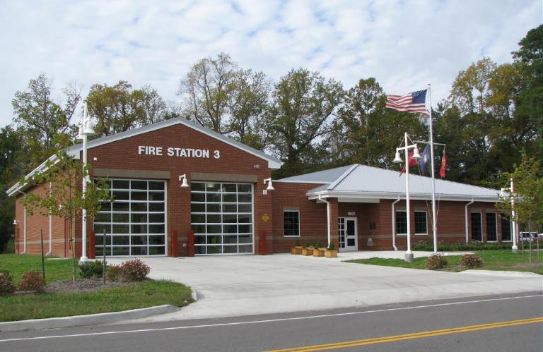
Engine 1 to all units, we've got a glow in the sky!
If God's not a Hokie, Then why do the leaves turn Maroon and Orange in the Fall?
My [url="http://www.flickr.com/photos/fotowun/"]Flickr Account[/url]
Posts: 218
Threads: 3
Likes Received: 0 in 0 posts
Likes Given: 0
Joined: Jun 2006
Reputation:
0
Memorial to Firefighters Young and Hudgins in front of the station.
Engine 1 to all units, we've got a glow in the sky!
If God's not a Hokie, Then why do the leaves turn Maroon and Orange in the Fall?
My [url="http://www.flickr.com/photos/fotowun/"]Flickr Account[/url]
Posts: 218
Threads: 3
Likes Received: 0 in 0 posts
Likes Given: 0
Joined: Jun 2006
Reputation:
0
Chesapeake Engine 3, responding on a medical just moments after I arrived at the station.
Engine 1 to all units, we've got a glow in the sky!
If God's not a Hokie, Then why do the leaves turn Maroon and Orange in the Fall?
My [url="http://www.flickr.com/photos/fotowun/"]Flickr Account[/url]
Posts: 218
Threads: 3
Likes Received: 0 in 0 posts
Likes Given: 0
Joined: Jun 2006
Reputation:
0
Station 3 came into existence in 1951 when Portlock was annexed by South Norfolk, isolating a corner of Norfolk County from the remainder of the county’s fire protection. I believe Fentress (On the same site as the present day CFD Station 6) or Great Bridge (The original CFD Station 5 after consolidation) would have been first in, and it would have been a hike for either fire company, on a road system nowhere near as good as the one enjoyed by modern day Chesapeake.
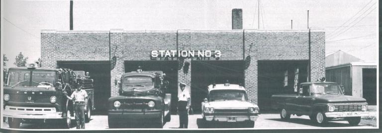
The new station was approved, bidded out, built, and occupied in 1951. Try getting a station approved and built in under a year now! This was (And is) the Washington Borough of Chesapeake, and the new fire company was christened The Washington Borough Volunteer Fire Department. After consolidation, the fire company kept this name. (In fact the name’s visible beneath the windshield of the Ford C Series rig) The name Indian River came much later.
Thanks to CFD Capt Sam Gulisano for the pic and permission.
Engine 1 to all units, we've got a glow in the sky!
If God's not a Hokie, Then why do the leaves turn Maroon and Orange in the Fall?
My [url="http://www.flickr.com/photos/fotowun/"]Flickr Account[/url]
Posts: 218
Threads: 3
Likes Received: 0 in 0 posts
Likes Given: 0
Joined: Jun 2006
Reputation:
0
Old Station today...directly across from the new station.
Engine 1 to all units, we've got a glow in the sky!
If God's not a Hokie, Then why do the leaves turn Maroon and Orange in the Fall?
My [url="http://www.flickr.com/photos/fotowun/"]Flickr Account[/url]
Posts: 218
Threads: 3
Likes Received: 0 in 0 posts
Likes Given: 0
Joined: Jun 2006
Reputation:
0
Station 4 B M Williams
Station 4 is at 104 Lenore Trail, at the intersection of Lenore Trail and Battlefield Blvd, just about T 3 or T 4 level of the knight’s back, and the left bottom point of the star.
Station 4 was built in 1962 in Norfolk County just before consolidation, and was likely built with that eventuality in mind.
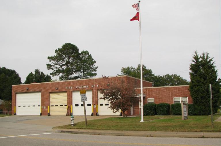
I couldn’t find a great deal of information on the fire company, but I’m assuming it went in service with maybe one or two salaried personnel and the remainder volunteers. Today Station 4 is home to the city’s marine response unit, two engines and a medic. Engine 4 and Medic 4 are the busiest engine and medic in the city.
Engine 1 to all units, we've got a glow in the sky!
If God's not a Hokie, Then why do the leaves turn Maroon and Orange in the Fall?
My [url="http://www.flickr.com/photos/fotowun/"]Flickr Account[/url]
Posts: 218
Threads: 3
Likes Received: 0 in 0 posts
Likes Given: 0
Joined: Jun 2006
Reputation:
0
Station 14. Greenbriar.
I’m going to throw Station 14 in here out of order to complete the star…Station 14’s located at 1200 Volvo Parkway, is the bottom right point of the star, and is located just inboard of the point where the knight’s right shoulder meets his neck.
Station 14 was built in 1988 as a combination fire station and Police precinct (5th Precinct) to provide better coverage to the rapidly growing northern area of the city. The guys I talked to at # 14 told me that the police presence a has been reduced considerably as a new precinct has been built on Research Dr.
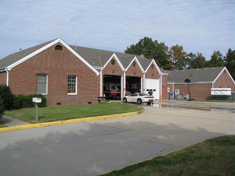
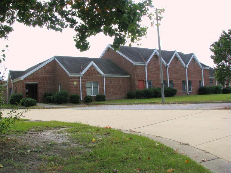
Due to the building’s dual purpose when constructed, the layout is interesting, with the bays opening in the rear of the building…The public entrance is over on what was the police side of the building. You come out of the bay, turn right, and have a fairly long driveway leading out to Volvo Parkway.
Engine 14’s crew was busily engaged in car-washing when I stopped by to grab a shot or two of the station around lunch time, and as was the case at all of Chesapeake’s stations, everyone was great. The weather was still on the warm side at that point, though it got chillier quickly as the afternoon progressed.
Engine 1 to all units, we've got a glow in the sky!
If God's not a Hokie, Then why do the leaves turn Maroon and Orange in the Fall?
My [url="http://www.flickr.com/photos/fotowun/"]Flickr Account[/url]
Posts: 218
Threads: 3
Likes Received: 0 in 0 posts
Likes Given: 0
Joined: Jun 2006
Reputation:
0
Station 14, Alpha Side
Engine 1 to all units, we've got a glow in the sky!
If God's not a Hokie, Then why do the leaves turn Maroon and Orange in the Fall?
My [url="http://www.flickr.com/photos/fotowun/"]Flickr Account[/url]
Posts: 218
Threads: 3
Likes Received: 0 in 0 posts
Likes Given: 0
Joined: Jun 2006
Reputation:
0
Station 5 Great Bridge
This was my third stop on my Wednesday trip, with the weather absolutely awesome.
Station 5 is located on Hanbury Rd, off of Johnstown Rd and just a bit north of the city’s dead center. The station was built both because of the old station’s age and smaller size as well as part of an effort to position the assigned companies more centrally in their first due area.
Station 5 is home to Engine 5, Ladder 5, Squad 5, Hazmat 5, Hazmat 25, Medic 5, Boat 5, Battalion 2, and Boat 2
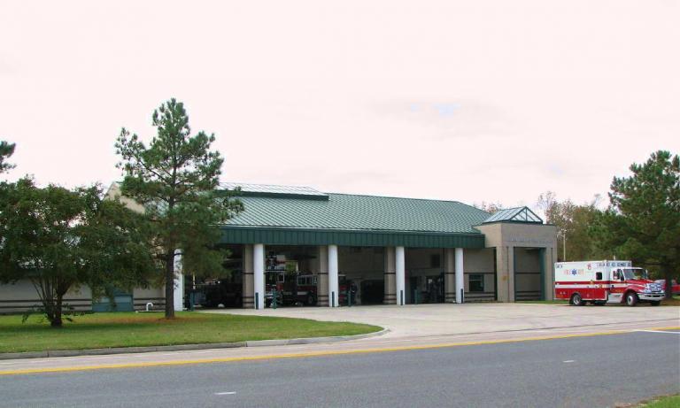
The station is huge, nice, and a BEAR to shoot because of hedges and such, and was even more so because the sun was in exactly the wrong place. Invitations to come back when they had time to pull rigs out were extended, and I had a blast getting shots of the rigs I could get shots of.
Engine 1 to all units, we've got a glow in the sky!
If God's not a Hokie, Then why do the leaves turn Maroon and Orange in the Fall?
My [url="http://www.flickr.com/photos/fotowun/"]Flickr Account[/url]
Posts: 218
Threads: 3
Likes Received: 0 in 0 posts
Likes Given: 0
Joined: Jun 2006
Reputation:
0
Great Bridge VFD was organized in the late 40s, with the original station opening in 1948 on Reservation Rd, about 2.5 miles away from the current station. This station was a joint effort of the Army Corp of Engineers and Norfolk County. I’m unsure of the Norfolk County company number as the numbers were changed after consolidation.
The Army Corp of Engineers donated the land (Worth $35,000 then) and the County built the building (10,000 dollars, and this was a nice station for that era!)
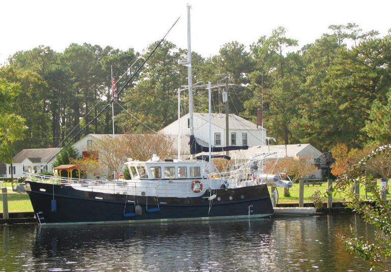
This station sits on what is arguably one of the coolest plots of land occupied at any time by any fire company in Virginia, and thus the reason The Corp of Engineers was involved. The Station property backs up to the old Chesapeake and Albemarle canal, then and now part of The Intracoastral Waterway. You can stand behind the building and look to the left at the Great Bridge Locks, and to the right (Only about 100 or so yards away if that) at the drawbridge carrying Battlefield Blvd across the canal.
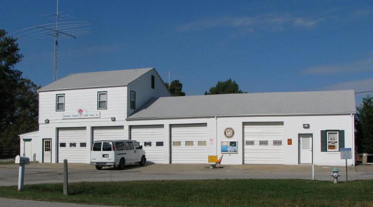
I ended up spending about 2 hours here, between old Station 5, the traffic on the canal (I got there only a few minutes before a scheduled bridge lift) and Great Bridge Locks park.
I have a feeling that this will be a fairly regular road trip when the weather gets warmer.
The Great Bridge area has another claim to fame as well. The Battle of Great Bridge…the first revolutionary War battle to be fought on Virginia Soil…was fought just north of the present day Intracoastal Waterway.
Engine 1 to all units, we've got a glow in the sky!
If God's not a Hokie, Then why do the leaves turn Maroon and Orange in the Fall?
My [url="http://www.flickr.com/photos/fotowun/"]Flickr Account[/url]
Posts: 218
Threads: 3
Likes Received: 0 in 0 posts
Likes Given: 0
Joined: Jun 2006
Reputation:
0
Shot of the 'C' side of Old Station 5, from across the Intracoastal Waterway.
Engine 1 to all units, we've got a glow in the sky!
If God's not a Hokie, Then why do the leaves turn Maroon and Orange in the Fall?
My [url="http://www.flickr.com/photos/fotowun/"]Flickr Account[/url]
Posts: 218
Threads: 3
Likes Received: 0 in 0 posts
Likes Given: 0
Joined: Jun 2006
Reputation:
0
Station 6 Fentress
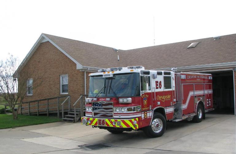
Station 6 is located at 1109 Whittamore Rd in the rural east central portion of Chesapeake, just below the knight’s right arm. The station was built in 1982, replacing a station built in 1951 on the same site. Engine 6 and Brush 6 call Station 6 home, and one of the target hazards in their first due in the Fentress Navy Auxiliary Landing Field, just a couple of miles west. The field was built in 1940 and is presently used to simulate a carrier flight deck for Carrier qualification training…the field sees approximately 140,000 flight operations annually.
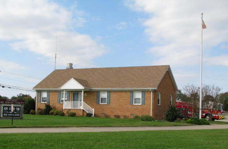
The station is ‘L’ shaped and built to resemble a ranch style house with the bays opening off of the rear of the building. Engine 6 was on the apron when I stopped by the station and grabbed a few shots. Were it not for the rig and the flagpole, the shots from the front could well be real estate pics of a nice ranch style house. The station is well layed out and comfortable inside, and has a definite home-like feel.
Engine 1 to all units, we've got a glow in the sky!
If God's not a Hokie, Then why do the leaves turn Maroon and Orange in the Fall?
My [url="http://www.flickr.com/photos/fotowun/"]Flickr Account[/url]
Posts: 218
Threads: 3
Likes Received: 0 in 0 posts
Likes Given: 0
Joined: Jun 2006
Reputation:
0
Station 6, bay with Engine 6 on the apron
Engine 1 to all units, we've got a glow in the sky!
If God's not a Hokie, Then why do the leaves turn Maroon and Orange in the Fall?
My [url="http://www.flickr.com/photos/fotowun/"]Flickr Account[/url]
|


 Facebook
 Google
 Reddit
 Twitter